Moogerah Peaks & Lake Moogerah: A Visual Spectacular
Phản hồi
Báo xấu
0 Lượt xem Premium01/08/2024
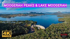
A winter morning hike/bushwalk was made to the top of Mount Edwards in the Moogerah Peaks National Park, with drone flights from a number of vantage points including the 2 different mountain lookouts, one was half way up & the other at the top of Mount Edwards, plus a flights from various locations around Lake Moogerah & Moogerah Dam.
Moogerah Peaks is a National Park in the Fassifern Valley of south sast Queensland, Australia, located approximately 70 km south west of the state capital Brisbane. The 676-hectare park consists of four separate protected areas which surround volcanic peaks and rocky cliffs near Moogerah Dam.
Mount Edwards rises 634 metres above sea level.
A hiking track takes you to the summit of Mt Edwards.
This trail crosses the dam wall then leads to the top the mountain.
There is a lookout part-way up the track with views of Little Mt Edwards/Reynolds Creek below the dam wall, while the lookout at the summit faces north-east towards Brisbane and the Fassifern Valley.
Moogerah Dam is a mass concrete double curvature arch dam with an un-gated spillway across the Reynolds Creek. It was completed in 1961. Water from the dam is used for irrigation along Reynolds Creek and also supplies water to Warrill Creek and Warrill Valley farmers through a series of diversions.
The peaceful blue waters are popular for recreational boating, water skiing and jet skiing.
Shot by Autel Lite, 4K, 30fps, M264, mp4.
Some shots are cropped.
Edited using Filmora 12.
Không được đăng tải lại nội dung khi chưa có sự cho phép của nhà sáng tạo
A winter morning hike/bushwalk was made to the top of Mount Edwards in the Moogerah Peaks National Park, with drone flights from a number of vantage points including the 2 different mountain lookouts, one was half way up & the other at the top of Mount Edwards, plus a flights from various locations around Lake Moogerah & Moogerah Dam.
Moogerah Peaks is a National Park in the Fassifern Valley of south sast Queensland, Australia, located approximately 70 km south west of the state capital Brisbane. The 676-hectare park consists of four separate protected areas which surround volcanic peaks and rocky cliffs near Moogerah Dam.
Mount Edwards rises 634 metres above sea level.
A hiking track takes you to the summit of Mt Edwards.
This trail crosses the dam wall then leads to the top the mountain.
There is a lookout part-way up the track with views of Little Mt Edwards/Reynolds Creek below the dam wall, while the lookout at the summit faces north-east towards Brisbane and the Fassifern Valley.
Moogerah Dam is a mass concrete double curvature arch dam with an un-gated spillway across the Reynolds Creek. It was completed in 1961. Water from the dam is used for irrigation along Reynolds Creek and also supplies water to Warrill Creek and Warrill Valley farmers through a series of diversions.
The peaceful blue waters are popular for recreational boating, water skiing and jet skiing.
Shot by Autel Lite, 4K, 30fps, M264, mp4.
Some shots are cropped.
Edited using Filmora 12.

 Phản hồi
 Báo xấu
 Phản hồi


![[Remix]Cảnh đánh nhau tuyệt vời trong <Gundam>](https://pic-bstarstatic.akamaized.net/ugc/0409fe02916b2569f786b628aad67630.jpg@320w_180h_1e_1c_90q.webp)


![Đây Không Phải Là Kéo Co Sao? EP 2 [Sub Việt]](https://pic-bstarstatic.akamaized.net/ugc/3e4c20a922e83727b5fb6ae04c9eeed9.jpg@320w_180h_1e_1c_90q.webp)


![Âm Dương Sư EP 4 [Sub Việt]](https://pic-bstarstatic.akamaized.net/ugc/f3612f4a01e123e37282ca5a111cd96b.jpg@320w_180h_1e_1c_90q.webp)
![Tôi Muốn Đi Ngược Chiều Gió EP 10 [Sub Việt]](https://pic-bstarstatic.akamaized.net/ugc/2590831f602e126821623abcb4b70f7b.jpg@320w_180h_1e_1c_90q.webp)
![Bài ca của linh mục [Mất toàn bộ]](https://pic-bstarstatic.akamaized.net/ugc/609c34a9f6047513f2d7669c77620587.jpeg@320w_180h_1e_1c_90q.webp)
